Record-smashing hurricanes and typhoons landed all over the world this month. During a pandemic. The untold story of the new mega-storms, ugly possibilities, and new science. Guest: scientist Pinaki Chakraborty from Okinawa Japan.
Listen to or download this Radio Ecoshock show in CD Quality (57 MB) or Lo-Fi (14 MB)
Right now, Europeans are groaning and grieving through a second wave of COVID-19. Sickness and death are striking many parts of the world, with India setting a grim toll and the virus knocking on the door of Pakistan. Russia is not publishing credible statistics, but it’s bad there. But the worst hit country in the world is without a doubt the United States of America.
As you try not to break down, hoping to survive another week, why talk about anything else? But other global events continue. The natural world has not stopped responding to our alteration of the atmosphere. Buried in the horror news of the pandemic is a another dark shadow. Have we just seen the first Super Storms?
Just last month, multiple hurricanes swept through the same zone of Louisiana. Then two Category 4 hurricanes smashed into Nicaragua and her neighbors. On the other side of the world, these mega-storms are called Typhoons. One of them strangely hit Somalia on November 22nd. NRP headline: “Somalia’s Strongest Tropical Cyclone Ever Recorded Could Drop 2 Years’ Rain In 2 Days”.
In the last three weeks, three big typhoons stuck the Philippines. The latest, Typhoon Vamco, flooded the capital Manila, broke dams, and submerged town and countryside. Vamco carried on to Vietnam, and then dumped unimaginable amounts of rain into the already soaked grounds further inland.
So we have big questions that urgently need answers:
are there more killer storms now due to climate change?
Are they following particular tracks? Why are these typhoons and hurricanes coming so close together? Why are inland cities getting storm floods? Are storms bigger now than before, and how long until we reach the age of superstorms beyond any human experience, as predicted by Dr. James Hansen and dozens more scientists?
I hope you are inside and safe. Let’s take this time to investigate the science, myths and big-time threats posed by violent weather in an unstable world. This is Radio Ecoshock. Welcome aboard.
You can watch my summary of science and predictions for more intense hurricanes and typhoons in this two part YouTube video series (taken from this show).
Storm Shock: 2020 Warning! Violent Weather – Record Smashing Hurricanes and Typhoons (23 minutes)
Part One (23 minutes)
Part Two (18 minutes)
***********************************************************************************************************************
If you can afford it, your help in financing this radio show and blog is always appreciated. It’s all I do, and our non-profit radio stations get the program for free, as do interested listeners all over the world, from our web site. You can make a one-time donation or a monthly membership here.
![]()
*************************************************************************************************************************
In a few minutes we will go to our guest in Japan, Professor Pinaki Chakraborty. His new paper in Nature warns hurricanes and typhoons are lasting longer, moving farther inland, flooding cities never previously part of the big weather events.
DANGEROUS HURRICANE ETA – THE NEW MODEL?
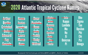
But first, think about Hurricane Eta. We were distracted with politics and human health when that news bounced by. Eta was a strange beast. This storm popped up on radar in the eastern Caribbean Sea on October 31 There was a difficulty naming it. So many hurricanes and tropical storms already boiled out of the Atlantic in 2020, that all 21 of the Roman letters used to name them were used up. There have never been so many big storms in one year. Is this the new stormy future under climate change? We will look at that science later.
Eta arrived later than any hurricane before it, striking the Caribbean islands and then Nicaragua in the first days of November. Hurricane season is supposed to be over by now. In a hotter climate, nobody knows how long the new hurricane season will be. Is it like the fire season in California, getting longer and longer?
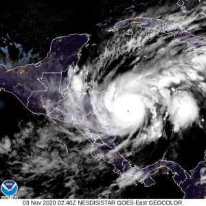
On November 3rd, Hurricane Eta ramped up from a Tropical Storm to a Category 4 hurricane in a matter of hours. From space, video of the sudden expansion of this monster is pretty scary. It is unsettling for everyone living near the coast to know any tropical storm could reach high levels quickly, and without the warning governments need to evacuate people. In Nicaragua, Eta stoked gusts up to 150 miles an hour, 240 kilometers an hour. This is the third most intense hurricane ever recorded in November – another awful record broken.
Rains were extremely heavy. Hills collapsed, landslides buried roads and houses, fields flooded and rivers burst their banks through parts of Honduras, Guatemala, Cuba, and even as far south as Panama and Columbia. Thousands of people were displaced. Whole swathes of homes were left roofless and damaged. Power was out and not coming back any time soon. All this is important to what came just two weeks later.
The election in Belize was still hampered by flooding 8 days later. Eta was not a fast moving storm. Remember, despite all their internal wind speed as typhoons and hurricanes rotate, they have no power of forward motion. These whirling banks of clouds and lightening are simply driven along by whatever local winds or upper atmosphere currents appear at the time.
The Cat 4 Hurricane Eta became a rain-laden tropical storm that hovered for days over Central America, before wandering over Mexico and out into the Gulf of Mexico as a weakened tropical depression. Winds were down to 35 miles an hour, or 56 kilometers per hour.
That was not the end of Eta. While many people over the world were fixated on the American election results, storm Eta reorganized in the Caribbean to hit Cuba on November 7. Defying prediction the great storm was blown north over the Bahamas and then into the south end of the Gulf of Mexico. Eta grabbed heat from the abnormally warm Gulf waters, briefly became a Hurricane again, then weakened to a tropical storm when it stuck the west coast of Florida, and drenched it’s way with flash flooding all the way up to the Carolinas and Virginia, killing 11 Americans.
WITH HURRICANE IOTA RIGHT BEHIND
That was just the warm-up act. Just two weeks later, the latest Category 5 Atlantic hurricane ever recorded struck the same part of Nicaragua again. Like Eta, Hurricane Iota was erratic, first showing as a weak tropical storm, then days later discovered as a Category 2 Hurricane over the Caribbean. Like Eta before, this storm exploded to Category 5 strength in hours. Seasoned observers were startled. Storms this big, this late, so close together – we have entered new territory. Climate change is showing us a new face.
Iota dumped epic amounts of rain, and again the landslides, roads out and floods stretched from Columbia to Mexico. Here is one thing we know: whether you call them hurricanes or typhoons, these big new storms are carrying more rain, and taking it further inland than ever before. And yes, it is because of climate change.Let’s go to our guest.
==================================================================================================
MORE RAIN, FURTHER INLAND THAN EVER BEFORE – PINAKI CHAKRABORTY
Professor Pinaki Chakraborty is co-author of a new study published November 11, 2020 in the journal Nature. The title is: “Slower decay of landfalling hurricanes in a warming world.” Professor Chakraborty is Principal Investigator for the Fluid Mechanics Unit at Okinawa Institute of Science and Technology, in Japan.

Dr. Pinaki Chakraborty, Okinawa Institute of Science and Technology
In the past, we assumed hurricanes were just a problem for people at or near the sea coast. In the last ten years or so, it seems the damage keeps going further inland. Pinaki and lead author Lin Li decided to check up on this.
In their new paper in Nature, I was interested to hear about “climate-modulated changes in hurricane tracks”. Pinaki explains this for us – and reports the landfalls in the United States appear to be moving Eastward over the decades. So a hurricane that might have hit New Orleans could now go for the Florida Panhandle? Check his explanation in the audio, available as a separate file below.
Download or listen to this 27 minute Radio Ecoshock interview with Pinaki Chakraborty in CD Quality or Lo-Fi
How do those changes in hurricane tracks slow down storm decay even more? In some cases, the new storm track may lead over a different geography. Where there are mountains, or even large cities, the storm may move more slowly, which in the new climate, means even more rain and flooding there.
At the end of August 2020 the island of Okinawa experienced Typhoon Maysak. There was some flooding but no loss of life. Less than a week later, Super Typhoon Haishen struck Japan and South Korea. It reached Cat 4 but then reduced to Cat 2 by landfall. This is just one of a series of tightly packed giant storms hitting across the world, from Nicaragua to the Philippines, and Japan before that.
To most people living through the pandemic, it seems like life will never be the same. But looking at science like the paper Li and Chakraborty published in Nature, we learn life will never be the same for a long, long time anyway – because we are in the process of destabilizing the climate.
In a follow-up email, Professor Chakraborty cautions against using the word “clouds” when discussing major storms. As we heard in the interview, there is a lot more to a hurricane or typhoon than the bands of storm clouds we see from the ground. The storm is a very complex mixture of forces, particles, water, ice, electricity and spaces under tension.
As a second note, I recall in an earlier Radio Ecoshock interview, a scientific guest reported the “drought line” currently in the central U.S. is drifting eastward. Is that shift in drought partly due to the change in steering winds high above, and the movement east of the tracks of hurricanes hitting the U.S. due to climate change, as described by Pinaki Chakraborty? Perhaps we need research to establish what the connections are, if any.
=================================================================================================
NEW STORM TRACKS IN OUR NEW CLIMATE
You might be in the new extended path of major storms. Pinaki’s description of research into storm tracks is important. It echoes what we find in a Washington Post article about a number of storms that crashed into the same region.
The classic case is Louisiana, specifically the coastal area West of New Orleans, toward the Texas border. An unbelievable five named hurricanes hit Louisiana in 2020. These include Cristobal, Marco, Laura, and Delta, and then Hurricane Zeta arriving on October 28.
Lake Charles Louisiana was struggling to patch up roofs blown off by Hurricane Laura at the end of August, when Hurricane Delta arrived at the same communities, a few weeks later. Residents were stunned. After being beaten up and threatened a couple of times, some may decide to leave what might be a new “hurricane alley”.
Matthew Cappucci of the Washington Post brought storm tracks into his article published November 17, 2020, following the second Nicaraguan hurricane, Iota. He chronicles the double hit of Cat 5 Hurricanes Irma and Maria in 2017. The Yucatan Peninsula of Mexico is another hurricane magnet. Cappucci writes:
“Between Tulum and Puerto Morelos, a Category 5, four Category 4s, a Category 3 and three Category 2s had made landfall through 2019. [In 2020] Delta and Zeta made landfalls as Category 2 and 1 storms respectively.”
There is a whole science of hurricanes tracks I’d like to dig into. Is it just the geography of ocean basins where land juts in? What is it about the great Mississippi River Valley that draws so many storms into the interior states? Or should we look at the meandering Jet Stream now changed in a warmer world?
===================================================================================
Find NOAA’s latest update (November 24) on the 2020 record-breaking hurricane season here.
“In total, the 2020 season produced 30 named storms (top winds of 39 mph or greater), of which 13 became hurricanes (top winds of 74 mph or greater), including six major hurricanes (top winds of 111 mph or greater). This is the most storms on record, surpassing the 28 from 2005, and the second-highest number of hurricanes on record.”
– NOAA November 24, 2020
Note that while the hurricane season is supposed to end on November 30th, it is possible to get big storms after that. As the future unfolds, we may see that assumption changed to December 15 or ???
On the noaa.gov web site, this US government agency says this about the cause of so many storms:
“This is the fifth consecutive year with an above-normal Atlantic hurricane season, with 18 above-normal seasons out of the past 26. This increased hurricane activity is attributed to the warm phase of the Atlantic Multi-Decadal Oscillation (AMO) — which began in 1995 — and has favored more, stronger, and longer-lasting storms since that time. Such active eras for Atlantic hurricanes have historically lasted about 25 to 40 years. An average season has 12 named storms, six hurricanes, and three major hurricanes.
‘As we correctly predicted, an interrelated set of atmospheric and oceanic conditions linked to the warm AMO were again present this year. These included warmer-than-average Atlantic sea surface temperatures and a stronger west African monsoon, along with much weaker vertical wind shear and wind patterns coming off of Africa that were more favorable for storm development. These conditions, combined with La Nina, helped make this record-breaking, extremely active hurricane season possible,’ said Gerry Bell, Ph.D, lead seasonal hurricane forecaster at NOAA’s Climate Prediction Center.”
=============================================================
THE BIG QUESTIONS
Let’s move to three central questions:
1. are hurricanes or typhoons actually stronger due to climate change, and are there more of them these days?
2. is the phenomenon of back-to-back hurricanes/typhoons new or increasing?
3. how do these 2020 power storms relate to the big paper led by James Hansen predicting ultra-super-hurricanes in the future?
1. ARE THERE MORE GLOBAL HURRICANES? APPARENTLY NOT.
The Union of Concerned Scientists says:
“There has been little change, however, in the frequency of hurricanes globally. Roughly 90 hurricanes occur each year around the world, with by far the greatest number occurring in the largest ocean basin on Earth–the Pacific.”
Here is the kicker: the number of hurricanes or typhoons each year has been fairly consistent, even with warming, but … when these storms do form, hotter sea surface temperatures tend to make more violent storms than before.
Let’s dive into a paper published March 15, 2013 by Greg Holland & Cindy L. Bruyère. The title is: “Recent intense hurricane response to global climate change”. This 2013 paper, using models and satellite observations, came to this conclusion:
“ a strong signal is found in proportions of both weaker and stronger hurricanes: the proportion of Category 4 and 5 hurricanes has increased at a rate of ~25–30 % per °C of global warming after accounting for analysis and observing system changes. This has been balanced by a similar decrease in Category 1 and 2 hurricane proportions, leading to development of a distinctly bimodal intensity distribution, with the secondary maximum at Category 4 hurricanes.
This global signal is reproduced in all ocean basins. The observed increase in Category 4–5 hurricanes may not continue at the same rate with future global warming. The analysis suggests that following an initial climate increase in intense hurricane proportions a saturation level will be reached beyond which any further global warming will have little effect.”
That was from the paper by Holland and Bruyere. The storm picture as we warm is not simple. The last sentence suggests there may be an upper limit to warming beyond which storms will not be further changed by more heating.
Also, while there may be more Cat 4 or 5 hurricanes, there have been fewer Cat 1 or 2. This suggests that if storms develop, they will become much stronger and dangerous, but some Tropical Depressions may not develop into weak hurricanes as before. They call that “bimodal intensity”. Either it’s weak and stays weak, or the storms boil up into monster hurricanes or typhoons. These authors think it is a “global signal” and so not limited to the North Atlantic versus the central Pacific or Asia.
A FORMULA FOR STRONGER STORMS AS WE WARM?
However, the authors note several other studies, and reports from the Intergovernmental Panel on Climate Change (IPCC) which conclude the frequency of intense hurricanes WILL increase as the planet warms. Holland and Bruyere write:
“the frequency of intense hurricanes will increase with future anthropogenic climate change. The increases are substantial, approaching a doubling in frequency of Cat 4 and 5 hurricanes for each degree C in global warming.”
Not all scientists agree, and predictions are particularly hard for the tropical Pacific typhoons. Even the IPCC remains unsure of the forecast for more storms.We have to be careful, as scientists and as citizens trying to inform ourselves, not to jump to conclusions based on this year’s extraordinary weather, or a storm you have been through personally. We need to cross-check with the records to see whether there really are more storms or not.
The respected scientist Kerry Immanuel got into this situation around 2005. After a string of very serious hurricanes, he predicted more hurricanes as the new normal. But a number of years that were very quiet in storm activity followed. Later, given another decade of observation and science, Immanuel modified his position. He says we can not be sure of having more storms, but those which develop would be stronger because of climate change. That has been verified by a continuing series of scientific papers, and by our experience.
Dr. Kerry Immanuel, MIT
The report Climate Change Impacts in the United States (2014) from the U.S. Government states:
“The intensity, frequency, and duration of North Atlantic hurricanes, as well as the frequency of the strongest hurricanes, have all increased since the early 1980s. Hurricane intensity and rainfall are projected to increase as the climate continues to warm.”
The latest science, including from James Kossin at the National Oceanic and Atmospheric Administration, says climate change is making storms stronger. In 2020, he told the New York Times, quote: “There’s this remarkable building of this body of evidence that we’re making these storms more deleterious.”
But maybe now we can add the possible rule that we might see a doubling of Cat 4 or 5 storms with each degree C. of warming. If that simple rule is true, and Earth warms by another 1 degree C by the year 2100 (or sooner) – we would see twice as many violent hurricanes then as we do now in 2020. If the planet warms by 3 degrees, that should mathematically predict not just twice, but four times as many storms. Would that be many months of hurricanes, almost back to back, as recently experienced in Nicaragua and the Philippines? We may have to live through it to find out.
BACK TO BACK HURRICANES
2. Now let’s talk about back-to-back hurricanes. Remember up until 2020, there have not been significantly more hurricanes or typhoons compared to previous decades. So why did 2020 produce one-after-another Categorized storms striking very close to one another in both time and place? We already mentioned the case of Louisiana, and the double storms that slammed Nicaragua and Central America generally. With our guest, we talked about two hurricanes about a week apart hitting Japan. But the worst case this year has hardly been reported in the West.
This isn’t something from the past. On November 18 the Sydney Morning Herald reported: “Three strong typhoons over the past three weeks have killed more than 100 people in the Philippines and damaged farms and infrastructure”. That just happened!
Three large storms striking the Philippineswere Typhoons Molave, Goni and then Vamco, last week. The first, Molave became a typhoon on October 25th. It then bounced off the Philippines in five different places, before striking Vietnam as the strongest storm in years. It killed at least 100 people and did hundreds of millions of dollars in damage, mostly to some of the poorest people in the world. Information about it’s aftermath is sparse.
THE STRONGEST STORM OF 2020
The next, Typhoon Goni was a monster, monster storm, rated as Cat 5, the highest rating. It was known in the Philippines as Super Typhoon Rolly. This was the strongest storm in the world for 2020, a year of many large hurricanes and typhoons. Scientists are now trying to rank Goni among the most intense tropical cyclones ever recorded. A million people were evacuated and almost 400,000 of them are still displaced, with no homes or farms to go back to. The evacuation centers are more dangerous because of the COVID-19 pandemic there. Rolly/Goni hit the Philippines at the end of August.
On November 11th, Cat 4 Typhoon Vamco slammed into the Philippines. That country has it’s own storm naming system, so in the Philippines Vamco is known as Typhoon Ulysses. Like Goni before it, Vamco hit several major islands of the Philippines. The capital Manila was badly flooded. A lot of infrastructure was damaged, which will take a long time to replace. A state of emergency was declared for all of the big island of Luzon. Clean up operations are still going on.
Past the Philippines, Vamco looked more of less spent, as a tropical depression over the South China Sea. But again, the ocean surface is hotter than in past decades. The storm picked up new power, spinning up again to a Cat 4 status. It weakened slightly to a Cat 2 before washing over Vietnam. There again, the sheer amount of flooding was unexpected. And parallel to the science we discussed with Dr. Chakraborty, Typhoon Vamco went further inland, dropping extreme rainfall. Central Vietnam all the way to Laotian border was flooded, again.
So what have we learned here? A fairly large group of scientists predict we will have more, and more violent, storms as the world heats up. If that is true, it makes sense the hurricanes or typhoons will tend to bunch up within the season that provides for their growth. This may be why we have repeat performances of these frightening storms.
But we also see that with such hot seas, storms don’t end as we might think. Instead of dissipating after crossing land, they can get re-charged over the next ocean basin, and show up again as Category 4 or 5 threats. The late season storms, both Eta and Vamco, seemed particularly charged by ocean temperatures, but that may be a one year observation. As these hurricane seasons extend, it may take a few years to gather meaningful records for the behavior of late-season storms versus earlier ones. This is all so new.
THE HANSEN SUPER STORMS
What if all the destructive giants we’ve seen in 2020 are small compared to what may be coming with climate change? One of the masters of climate science, Dr. James Hansen worries often about superstorms coming. Back in 1988, Hansen was the first to warn Congress about the threat of global warming. He was the long-time Director of the NASA Goddard Institute for Space Studies. In March 2016, James Hansen led eighteen other accomplished scientists to publish a very large scientific paper which was almost a compendium of Hansen’s greatest worries for the future, and challenges for climate science.

Dr. James Hansen NASA (retired)
The title is: “Ice melt, sea level rise and superstorms: evidence from paleoclimate data, climate modeling, and modern observations that 2 °C global warming could be dangerous”. I have interviewed a couple of his co-authors, including Isabella Velicogna in a 2016 show called “Dark Climate – Now and Coming”.
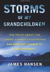
In today’s program we want to focus on what I will call “Hansen’s superstorms”. Keep in mind Jim Hansen’s main book for the public, released in 2010, is titled “Storms of My Grandchildren: The Truth About the Coming Climate Catastrophe and Our Last Chance to Save Humanity”. Even so, despite his preoccupation with storms, Hansen said in a video that rising seas were an even bigger threat to civilization.
Reading the big 2016 paper, we find the scientists are not necessarily talking about hurricanes as such. They say:
“Many of the most significant and devastating storms in eastern North America and western Europe, popularly known as superstorms, have been winter cyclonic storms, though sometimes occurring in late fall or early spring, that generate near-hurricane-force winds and often large amounts of snowfall (Chapter 11, Hansen, 2009).”
I like the way this was described by blogger and professional threat analyst Robert Marston Fanney, also known as Robert Scribbler. This is from his April 2016 blog:
“But for more than twenty years Dr James Hansen has been warning that the out-flush of cold water from glaciers in Greenland and Canada into the North Atlantic could set up a storm-producing weather pattern the likes of which human civilization has never seen. An atmospheric wrecking ball in the form of an intense cold-hot dipole that, once firmly established over Atlantic Ocean waters between North American and Europe, would carry on in brutally destructive fashion for decades and decades. In other words, as Dr. Hansen says in the below video, ’all hell would break loose.’”
Jim Hansen’s explainer video was published on YouTube on March 21st, 2016.
In the 2016 paper, Hansen and team travel back in time to explore boulders bigger than gravel trucks, tossed far inland in the Caribbean islands. They wonder if storms beyond our experience put them there. But are we already arriving at the conditions these scientists suggest will create ultra-super storms?
The main requirements are two: higher sea levels, and so much meltwater pouring off Greenland that it turns the mighty Gulf Stream further south. Sea levels are climbing, but in other works, Hansen has projected much higher levels this century than mainstream science has published (in works like the IPCC reports). Where conservative scientists suggest one meter – three feet – higher seas by the end of this century, more and more I hear one meter by 2050, and three meters – almost 10 feet! – higher seas by 2100.
The second premise for superstorms is diversion of the Gulf Stream. Really, it is much more than the Gulf Stream that east Coast Americans take for granted, and that keeps Britain and North Europe warmer than their latitude should grant them. The whole ocean current system is called AMOC, short for Atlantic Meridional Overturning Circulation.
AMOC is the underwater pump that draws warmer waters to the Arctic and North Europe, before sending them below for a slow trip toward the southern ocean. The pump is mainly driven by the different weight of salt in the sea water. Heavier, saltier water drops down below, while lighter fresh water floats above. But that pump could be broken if too much freshwater pours off melting Greenland. The science-fiction movie “The Day After Tomorrow” imagines AMOC breaking down very quickly, appearing suddenly at remote measuring stations in a matter of days. But what about the real world?
Scientists and satellites are indeed measuring a large pool of colder, fresher water forming in the Atlantic just south of Greenland. In a world where all the seas are getting hotter, the Greenland blob and another along the melting coast of Antarctica, are the exceptions.
There is continuing science on the health of the Gulf Stream and the whole overturning system. The consensus finds the Gulf Stream has been weakened by 15-20%, compared to 1950. That is a significant change, but certainly not a major disruption yet. Rummaging through the Internet, a dozen scientific papers, and some of my previous guests, I conclude we have not met the conditions required for a new age of super-storms of the type Hansen fears – yet.
We may see hyped-up winter storms hitting Britain again, like the relentless bunch harrying the UK in 2013. That is a storm track that pops up. By the way, a 900-mile-wide Atlantic storm hit the UK at the end of September this year.
Regarding the case of cooling Britain and Northern Europe due to weakening of AMOC, there is another possibility: perhaps general warming will reduce those “little Ice Age” expectations or even overwhelm those ocean current impacts, so the UK and Northern Europe continue to warm, but warm less than they would have without the AMOC changes. We have a precedent for this. Several scientists on this show, including Kevin Trenberth who has published on ENSO for decades, say the arrival of El Nino or La Nina are still major factors for weather in the Americas and beyond – but that signal has been overtaken by human-made warming. ENSO is no longer the driving force. The same could be true for expectations about a weakening AMOC. Again, we don’t know how this will all unravel, as we create a shift in Earth’s energy balance.
Australian scientist Andrew Glikson warns the Greenland meltwater could trip a switch creating a major cooling in the North, called a “stadial freeze”. He told me:
“Temperatures would drop in high latitude regions and still keep rising in the tropics and sub-topics. Not that this is necessarily ’good news’ since the consequences of extreme storminess would cause havoc due to clash of extreme weather fronts, in particular in marginal island systems and continental margins.” See Glikson’s paper published May 31, 2019 in Climatic Change, titled “North Atlantic and sub-Antarctic Ocean temperatures: possible onset of a transient stadial cooling stage.”
I don’t know if or when a cold period might hit Eastern Canada, Britain and Northern Europe. I’m not sure anybody does. Just the fact that such large consequences are out there, unknown, should be a big red flag for rapid climate action!
If there is a connection between the cold blob below Greenland and the record number of tropical hurricanes and typhoons in 2020, I haven’t seen it published yet. For now, we can discount an early arrival of the Hansen ultra-super storms. Most scientists go back to the two forces we know about: rising seas, which add height to storm surges, and critically, hotter sea surface temperatures.
Of course when it comes to damage and lives lost, there are other factors. World population is still expanding rapidly. There has been a mass migration toward the coasts in many countries, from America to China and beyond. People build mansions, or hovels, right in the storm paths, right on the scenic ocean. Global trade has accelerated port growth and industry right near the sea.
Even so, when Cat 4 or 5 storms roll in, there is always going to be massive damage, including to food production. Now we know hurricanes and typhoons are carrying more water, and dumping it further inland than ever before. Each time, cities try to rebuild. Insurance companies pay until they can pay no more. Most insurance companies in America have stopped selling near the Gulf of east coast. Homeowners buy insurance from the government, which means all tax payers are hit with each mega-storm.
Coupled with rising seas, these super storms could force relocation of airports near the sea and eventually flood big underground systems like Boston’s “big dig” and the Manhattan subway system. Over the coming years, humans will have to give up ground to the sea. Storms are the exclamation marks to that death sentence.
I put a list of some previous Radio Ecoshock interviews with scientists about the threats and challenges of super storms down below. Dig in to find out for yourself.
****************************************************************************************************************************************************************************
If you can afford it, your help in financing this radio show and blog is always appreciated. It’s all I do, and our non-profit radio stations get the program for free, as do interested listeners all over the world, from our web site. You can make a one-time donation or a monthly membership here.
I’m Alex Smith. Thank you for listening, and learning about our new world.
============================================================================================
RADIO ECOSHOCK COVERAGE OF HURRICANES
Hurricanes and Arctic Fires: A World Slipping Away Unnoticed
Posted on October 21, 2020
Hurricanes and Arctic Fires: A World Slipping Away Unnoticed
Why are so many hurricanes hitting Mexico and the U.S. this year? Maria Gilardin of TUC radio guest hosts a new interview from hurricane central in Florida. Award-winning journalist Alex Harris of the Miami Herald interviews Rutgers scientist Jennifer Francis.
—————————–
LEARNING FROM HURRICANE IRENE
Growing Through The Storm
Posted on September 7, 2011
“Peak Oil Shrink” psychologist Kathy McMahon starts out. Watching the TV reports, and being kind of a “prepper” – Kathy got caught in Hurricane Irene in Vermont.
As the roads washed out, making a strange journey home, Kathy learned to watch what is developing in the actual emergency around you, rather than going by TV forecasts. What wasn’t predicted: the real problem in New England was not high hurricane winds, but the extreme rainfall event. You’ve heard Vermont was very hard hit. Not just the mountain roads, but even parts of the Interstate system were flooded out, along with bridges. The Interstate is supposed to be built for the “100 year flood”. I guess we just had that. Kathy has a lot more to tell us about our psychology in an emergency, how we handle ourselves in stressful times. I think this is a really useful interview.
[Is there helpful info in this show for our pandemic now? Check it out]
——————
STORMS OF RIGHT NOW
Posted on December 18, 2014,
Sandy, climate & coming superstorms: Kathryn Miles & Dr. Adam Sobel.
Predictably, the only fiery criticism Kathryn received after writing “Superstorm: Nine Days Inside Hurricane Sandy” was from Meteorologists! Some weather specialists still don’t get the long-term storm implications of climate change. Some continue to deny climate change plays a role.
Others, and certainly the climate scientists she interviewed, are certain a warmer world plays several key roles in extreme storms.
1. this warmer world holds at least 4% more water in the atmosphere. That gives storms more power, and can cause extreme rainfall events, as happened during Hurricane Irene.
2. the oceans are measurably hotter. It turns out, the ocean off New England is quite bit hotter during the last few years. That also adds to the power of extreme storms.
3. the seas are rising. I’ll talk more about this with our next guest Adam Sobel. The water around New York City is about one foot higher than it was in the year 1900. There are several reasons for that, it’s not just climate change. But a higher sea adds to the storm surge, and that was the most damaging part of Hurricane Sandy.
Climate scientists are less certain about other impacts of a warming world. Most think we may get fewer hurricanes or tropical cyclones, but the ones that do come will be more powerful. There’s a lot we don’t know for sure about that.
The U.S. currently has 500 un-staffed positions in the National Weather System, including staff needed to run radar and work. Their budget cut by 8.5%. America has Doppler radar that crashes, satellites beyond their lifespan. The Hurricane warning service has to borrow from other countries, including some excellent work done by Cuba. This weakness in predicting extreme weather is a national crisis, and a personal threat.
—————–
Death in the Bahamas & Smoke Over the Arctic
Posted on September 18, 2019
We talk about the deadly storm Dorian with Canadian scientist Paul Beckwith.
Beckwith wondered if tens of thousands of Bahamians died in Hurricane Dorian. Currently Wikipedia says only 70 did. But get this recent headline:
Bahamas has no idea of Dorian death toll after names of the missing were removed from list
BY JACQUELINE CHARLES JUNE 12, 2020
“The Bahamas’ former health minister says the country so badly botched its record-keeping on Hurricane Dorian’s missing victims that today it cannot say with certainty how many people actually died in the horrific storm. Dr. Duane Sands, speaking in the country’s Parliament on Thursday, said the Bahamas should convene a coroner’s inquest to help bring closure to grieving families. Thousands of names of the missing after the hurricane disappeared off the missing-persons list, he said, without explanation.
Dorian hit the Abacos and Grand Bahama over Labor Day weekend in September 2019 as a catastrophic Category 5 storm, and the most powerful hurricane to ever hit the archipelago southeast of Florida. The storm came to a near-standstill over the islands, leaving major devastation. According to Sands, the official death toll was 74.”
——————
Smash the Carbon Nightmare
Posted on May 1, 2019, by Radio Ecoshock
Atmosphere specialist David Keellings on the new age of super-hurricane/cyclones
DAVID KEELLINGS: CLIMATE-ENHANCED HURRICANE MARIA
On September 20th, 2017 record-smashing Hurricane Maria hit Puerto Rico. Thousands died because of it. New science confirms the devastating rains and floods during Maria were far more likely due to climate change.
According to recent data from the US Census Bureau, after the storm about 4% of the population of the island fled for the United States mainland. They are among the new American climate refugees, joining those from Hurricanes Harvey and Katrina.
The new paper is titled “Extreme Rainfall Associated With Hurricane Maria Over Puerto Rico and Its Connections to Climate Variability and Change.” We have reached the lead author, Dr. David J. Keellings, Assistant Professor in the Department of Geography at the University of Alabama.